…the town, with its meadows, streams, the hills rising up nearby, its woods, and the orography of the Slizza stream, forms a natural setting of uncommon panoramic beauty…
[from the Decree for the Protection of the Tarvisio Territory Ministerial Decree of 15/05/1956]
Tarvisio: a mix of culture
Stopping in Tarvisio, even for just a few days, you’ll hear different languages—Italian, Friulian, German, Slovenian—you’ll learn about the popular traditions and folklore of diverse cultures, and you’ll discover the distinct flavors of Friulian, Carnian, Carinthian, and Slovenian cuisines in the food.
This diversity is fostered by the fact that the Tarvisio area, like much of Friuli, has for centuries been a transit point between the Veneto-Po plains and the regions of Central and Eastern Europe, and the passage of so many peoples has facilitated the circulation of ideas, people, and goods.
The village dates back to Roman times, and its history continues into the Middle Ages, when, starting in 1007, it became part of the Bishopric of Banberga.
Centuries of rural and then commercial development followed, with the granting (1456) of an annual fair that still survives today, and thanks to the transit route between Carinthia and Venice.
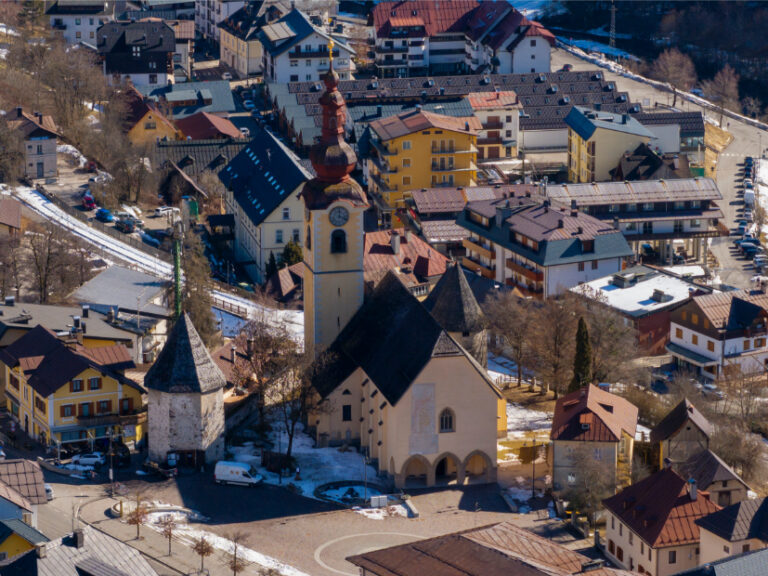
There were periods of peace, but also wars and invasions. For example, at the end of the 1400s, Tarvisio was sacked by the Turks, and it was during that period that the church you see in the town’s main square was fortified with towers, walls, and moats.
In 1758, the Bishopric of Bamberg ceded Tarvisio to the Austrian Empire.
And except for a French interlude during the Napoleonic era (early 1800s), Tarvisio remained in the Austrian Empire until 1919, when, following the end of the First World War, it became part of the Kingdom of Italy.
The Church and Other Monuments
Tarvisio is more than just nature: it is also a place rich in Alpine history and art. Among its beauties, the Church of Saints Peter and Paul stands out, with ancient frescoes and a serene atmosphere.
The church is an architectural jewel that reflects the region’s rich history and cultural influences. Founded in 1399 on the site of an earlier 11th-century chapel, the current structure was completed in 1445. In 1960, the church underwent a significant expansion toward the square, during which important frescoes were discovered and restored, including a large 16th-century Saint Christopher, now visible on the façade.
The interior of the church houses valuable works of art, such as a stained-glass window depicting Emperor Henry II the Saint, who donated the lands of the Valcanale to the Bishop of Bamberg in 1007. Among the frescoes, a depiction of Charles V on horseback, dating back to 1532, and scenes from the Last Judgement and the Life of the Virgin Mary stand out.
Beyond its artistic value, the church also served a defensive purpose: in the 15th century, it was surrounded by walls to protect the population from Turkish raids, making it one of the most interesting examples of a fortified church in the Alpine region. Municipality of Tarvisio.
Next to the church stands a striking medieval octagonal tower, built in the 15th century as part of the defense system against Turkish raids. Today, this well-preserved tower represents a precious testimony to the city’s historical past and occasionally hosts temporary exhibitions, offering visitors a fascinating insight into local history.
Behind the Church of Saints Peter and Paul are the Holy Trinity Column, a Baroque religious monument, and several Roman tombstones that bear witness to the city’s long history.
In Tarvisio Boscoverde, you’ll find the Monument to the Austrian Grenadier, erected in 1909 by sculptor Josef Valentin Kassin, commemorating the soldiers of the Habsburg army who fell during the Napoleonic Wars. The bronze statue depicts a grenadier in uniform, with rifle and bayonet, and stands on a rocky outcrop overlooking the valley.
Walking through the village, you’ll discover ancient wooden houses, historic fountains, and evidence of the border culture, where Italian, Austrian, and Slavic influences coexist.
The Territory
The town center is located at an altitude of 754 meters and is surrounded by the Julian Alps, which include several higher peaks—Mangart (2,668 m), Jof Fuart (2,666 m), Jof di Montasio (2,753 m), and Canin (2,587 m)—as well as lower peaks, including Mount Lussari, well-known for its sanctuary.
Magnificent valleys open up at the foot of the mountains, including Val Saisera and Val Bartolo.
The ancient Tarvisio forest covers mountains and valleys, crossed by rivers and streams (Fella, Slizza, Bartolo, etc.) and including the Fusine lakes (Lago Superiore and Lago Inferiore) and Lake Raibl (Predil).
Interesting Facts
Some interesting facts about the Tarvisio area:
- It has a very large territory, over 200 square kilometers, larger than the Municipality of Milan;
- It is one of four Italian municipalities to border two different foreign countries (Monte Forno);
- A large portion of its territory lies north of the Italian Alpine watershed (Camporosso Saddle), where the waters of the Slizza River flow into the Gail River and then into the Danube, before flowing into the Black Sea;
- It contains the largest state-owned forest in Italy, excluding parks, with 24,000 hectares of Alpine terrain, 15,000 of which are covered in productive forests;
- Despite being only 754 meters above sea level, it experiences very cold winters that can bring very low temperatures, with a recorded low of -23 degrees Celsius in 1985.